
However, in the northern regions of the larger islands, predominantly cloudy skies will prevail, meaning there is a possibility of light, occasional rain.
MADRID/SANTA CRUZ DE TENERIFE, 21 Sep. (EUROPA PRESS) –
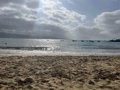
The Canary Islands will begin the week with generally clear skies, except for some intervals in Lanzarote and Fuerteventura during the early and late hours of the day, as well as in the west and south of the western islands during the afternoon, according to forecasts from the State Meteorological Agency (Aemet).
However, in the northern parts of the larger islands, cloudy skies are expected with a likelihood of light, occasional rain, particularly in the mid-altitude regions.
Meanwhile, temperatures are set to decrease generally, with more significant reductions in maximum temperatures. Thermometers will range from a maximum of 28 degrees in Tenerife to a minimum of 18 degrees in El Hierro.
As for the wind, it will be moderate from the northeast, with gusty intervals in the southeast and northwest slopes. Coastal areas in the southwest of the mountainous islands will experience breezes.
REST OF THE COUNTRY
The influence of an Atlantic trough, along with the passage of an Atlantic front across the Mediterranean, will lead to continued temperature drops across the peninsula this Monday. This will particularly affect the northernmost regions, where it will be accompanied by rainfall that could be locally heavy along the coasts, with significant accumulations expected in Asturias and Cantabria.
According to forecasts from the State Meteorological Agency (Aemet), a general decline in temperatures is expected, with notable decreases in maximum temperatures especially in southern Iberian areas and locally in La Mancha, while no changes are anticipated in the northwestern coasts and Upper Ebro.
Thus, only four provincial capitals—Málaga, Murcia, Córdoba, and Granada—are expected to reach or exceed 30°C during the central hours of the day. The rest will see maximum temperatures between 15 and 29 degrees.
GRADUAL DARKENING OF THE SKIES
Similarly, minimum temperatures will also drop on Monday across Spain, with few communities exceeding 15°C. Regions like Castilla y León and the Basque Country will experience temperatures more typical of autumn or winter, such as Burgos (3°C), Soria (4°C), Segovia (5°C), and Vitoria (6°C).
Furthermore, as the front passes and the trough influences the weather, a gradual darkening of the skies is forecast for the extreme north, eastern third, and the Balearic Islands, while the rest will remain mostly clear, except for some evolving clouds in the northern plateau and eastern third.
In some areas of the extreme north, the northeastern peninsula, and the Balearic Islands, rain and showers are expected, with the possibility of localised heavy rainfall along the coasts and significant accumulations in Asturias and Cantabria.
Strong to locally very strong showers accompanied by thunderstorms are also anticipated in the northeast and the Balearic Islands, tapering off by the afternoon. In the Canary Islands, only cloudy intervals with a light shower are expected in the mountainous areas.
On the wind front, it will blow moderately from the west and north, with intervals of strong gusts and very strong gale-force winds likely in the lower Ebro and tramontana in Ampurdán, alongside expected strong winds along the Cantabrian coasts.
In the Canary Islands, a moderate trade wind is anticipated, with intervals of strong winds in exposed areas.


